


What is lake effect snow?
 Print
Print Email
EmailUnderstanding Lake Effect Snow – using the Teaching Great Lakes Science resources from Michigan Sea Grant
The Great Lakes create unique weather patterns. One of those weather patterns is lake effect snow. Lake effect snowstorms occur in only three pl aces in the world: the Great Lakes, the east shore of Hudson Bay and along the west coasts of the Japanese islands of Honshu and Hokkaido. While people in the snow belt regions have learned to adapt, living near the lakes and experiencing lake effect snow still affects the economy and culture in significant ways. For example, winter sports like skiing and snowmobiling are major industries in some northern states. This information, and the related Teaching Great Lakes Science lesson, explores how the Great Lakes influence lake effect snow, other factors that contribute to lake effect snow, and ways of reading weather conditions to forecast lake effect storms.
Causes of Lake Effect Snowstorms
Weather is caused by large temperature differences between the land and water (learn more about the Great Lakes as a heat sink and heat source in the Keeping it Temperate TGLS lesson). During the unstable seasons on the Great Lakes, temperatures can change quickly over the land. Here is an overview of how that can happen:
- Mid-August to March: The average temperature of the land is colder than the average temperature of water.
- Mid-November to mid-January: This time of year sees the largest temperature differences between land and water.
- Those temperature differences may average 30 degrees Fahrenheit (F) (17 degrees Celsius) in the northern lakes and more than 15 degrees F (8 degrees C) in the southern lakes.
 Arctic air moving across the lakes by northerly winds can drive temperature differences as wide as 50 degrees F (28 degrees C) in the north and 40 degrees F (22 degrees C) in the south. These temperature differences between the land and water are the source of what we call weather. Arctic air, necessary for lake effect snow, usually comes after a deep low-pressure center has passed through or near the Great Lakes region. As the low pressure center moves through, it opens the way for cold air to rush southward. Cold air usually moves through in the form of a high-pressure area behind a cold front. Snowfall regularly occurs in conjunction with a rising barometer.
How Lake Effect Snow Forms
- Cold air streams across the warm lakes. Air warms and becomes more humid.
- As the air warms, it becomes less dense and rises.
- As air rises, it cools.
- Cooler, moist air may form clouds and cause precipitation (e.g. rain, sleet or snow).
- After the air has moved some distance over the lake, convection and turbulent exchange have transported the moisture upwards to form clouds.
- Once over land, moisture in the air condenses into snow. Snow created in this way is called lake effect snow.
- As the warmed air reaches the shoreline, additional lifting may occur as the air begins to “pile up.” Air typically moves more slowly over land than over water.
- Hills and elevated land areas on down-wind lake shore areas force air upward. Air cools further, encouraging cloud formation and greater snowfall.
As the cold air streams across the warm lakes, it is warmed and becomes more humid. As the air warms, it becomes less dense and tends to rise. Whenever moist air rises, as 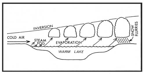 previously noted, clouds may form and precipitation may result.
Fog results from the intense evaporation or transfer of moisture from the warm water to much colder air when the cold air initially makes contact with warm water. After the air passes some distance over the lake, convection and turbulent exchange have transported the acquired moisture aloft to form clouds and snowfall may occur.
Clues for Predicting Lake Effect Snowstorms
The following conditions are necessary for lake effect snowstorms. Each of the factors below must be present for a storm to occur:
- Large temperature difference between the lake and air. The greater the difference, the larger the potential for lake effect.
- High pressure cell (rising barometer) following a low pressure cell (falling barometer). This situation provides favorable conditions for lifting the warm, moisture-filled air upward for cooling and ice crystal formation.
- A long fetch - Fetch is the distance the wind travels over the open water surface. The longer the fetch, the greater the amount of heat and moisture that may be acquired from the lake, resulting in greater potential for lake effect snow. For example, a northwest (NW) wind travels almost 130 miles (210 km) across Lake Superior, 150 miles (242 km) across Lake Huron, but only about 30 miles (48 km) across Lake Erie. More lake effect snow would therefore be expected from a NW wind on the southeast shores of Lake Superior and Lake Huron than Lake Erie.
Lesson for Educators: Examining the Lake Effect - Students examine lake effect snow in the Great Lakes region, including how to forecast lake effect snow, where it might occur, and what effects it may have on the people of an area.
Additional suggested reading: Climate Change Leading to More Snow?


