


What do the official looking tags on trees scattered across the state indicate?
 Print
Print Email
EmailEstablished for a variety of reasons over a long period of time, tagged trees may provide valuable information for researchers helping insuring the long-term health and viability of our states forest and urban tree resources.
In addition to the many “No Trespassing”, “No Hunting” and other property boundary signs one might encounter tacked to trees all across our region, hikers and travelers may also come across unique and specialized tree signage. Depending on the reason they were placed on the trees they may either provide valuable information for wayward trekkers or help to identify trees being used in important research.
A comprehensive listing of the all various identification tags one might run across in their travels would just be too extensive to list here. However, three important ones that are likely to be encountered across Michigan would include:
Superior Tree – In the early 1970s the US Forest Service (USFS), in an effort to identify trees of superior genetic quality and form, established the Superior Tree program. An effort was undertaken to identify the location of trees with superior genetics that could be used for seed harvest to provide stock for high quality future forests. Once identified, trees were labeled with bright yellow ID tags, with the individual tree’s location and information recorded in a USFS data base.
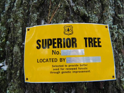
USFS Superior tree tag on a white pine in Houghton Co. (Deborah Hilscher photo)
Sentinel Trees – Beginning this year, a network of volunteers are monitoring select sentinel trees across the state for overall health. The primary goal of the program is to look for and identify possible new introduction of invasive pest species. This Michigan State University Extension (MSUE) program has been established to give early notification of populations of insects and diseases that pose a threat to our tree resources. It is hoped that through early detection widespread loss of select tree species can be prevented.
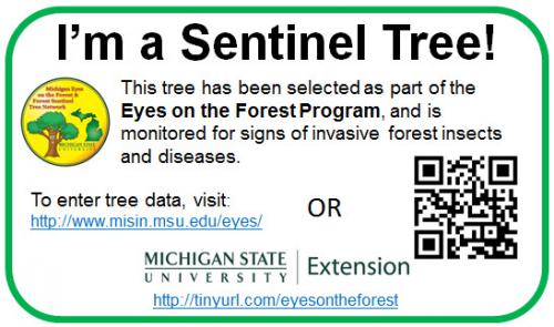
MSUE Sentinel Tree tag (Georgia Peterson etal. Photo)
Survey Corner Tags: Along roads and trails, resource professionals or surveyors will place aluminum (really old ones may be yellow enamel on steel) tags with distance and compass direction to a nearby survey corner. Useful in finding corners for establishing property lines, these tags may also help trekkers temporarily lost in the back country figure out where they are and assist in getting back to a known location. These kinds of tags are most likely encountered in northern, more remote regions without a patterned road grid system.

sample survey corner tag
Should someone encounter one of these or another type of tag on a tree they may be checked out or made note of, but please leave them undisturbed. Someone somewhere placed the tags for a specific purpose and they will be necessary for future reference. Other tags one might encounter may include tree species ID tags, which are used by many municipalities to inventory street trees. Name tags are for species identification in park or recreational areas, whereas numbered tags are used in research projects.
The MSUE Eyes on the Forest program offers interested citizens an opportunity to identify a “sentinel tree” along with obtaining and reporting health and growth information. Tree tags like the one highlighted above are provided to identify individual trees. With diligent annual monitoring it is hoped new populations of tree pest species can be detected early enough in their incursion to allow for eradication of these potentially devastating tree killing invasives.
Sentinel Tree volunteers are needed, so if you would like to be an active participant in this program, please let us know. You can contact Mike Schira at schira@msu.edu or Russ Kidd at kidd@msu.edu if you’d like to volunteer. Active participation will offer an opportunity to “tag” a tree and become more than a spectator.


