


Using sector planning to strengthen master plans
 Print
Print Email
EmailSector plans provide a means of directing growth without the use of land use categories in the near future.
Most Michigan communities have a master plan of some sort, and contained within that plan is a future land-use map. This map typically shows what the community wants to become after twenty years of growth. A lot of things can go wrong or change in that time span.
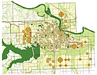
So how does a community manage that time frame within their plan? A technique that is gaining in popularity is the use of sector mapping. Instead of mapping a community into future land use classifications such as residential or commercial, areas are mapped as growth or infill sectors. Growth sectors are typically divided into intended growth sectors and controlled growth sectors. Infill sectors are those targeted areas for development of vacant lots, or intensification of existing development patterns. One key attribute of all sectors is a mix of uses. This mix of uses allows for complete communities that contain places to live and work, in addition to shopping and utilizing civic spaces.
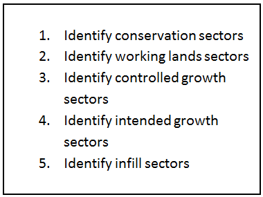
The process is relatively straightforward. It begins with identifying the natural areas that should not be developed as well as working lands that need to be kept as such. The next step is identifying the controlled growth areas, such as low density suburban development and other areas without the infrastructure necessary to support much more growth. There may be some development potential in these areas, but they are not areas that can/should support intensification of use. Mapping the intended growth sectors - those areas with existing infrastructure and potential for reaching a density that will support transit - is the next step. These are the areas where development is targeted. What remains are the infill areas that contain the highest density and brownfield redevelopment areas and mapping these areas is the last step. These areas are maintained at the current level of density and redevelopment of parcels matches the existing density.
Sector mapping is a useful tool in developing policies to direct growth in communities in order to create complete neighborhoods with a mix of uses. It can lead directly to farmland preservation policies, infrastructure planning, transit development/expansion, and infill incentives for job creation. The largest benefit for communities is the ease of creating zoning codes based on a sector map. A sector plan becomes the basis for zoning districts on a zoning map or a regulating plan for form based codes. For more information on sector mapping and how it could be applied in your community contact Michigan State University Extension or your local Government and Public Policy Extension educator.


